Europe - Open Buildings Dataset
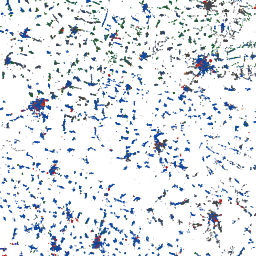
The Europe Open Buildings dataset is a continental vector layer of building footprints
derived by conflating three sources: AI-detected footprints from Google Open Buildings,
Microsoft Global ML Building Footprints, and crowd-sourced OpenStreetMap data. Classified
using the Global Earthquake Model (GEM) building taxonomy, it provides occupancy type
and estimated building height for each footprint. This layer is valuable for multi-hazard
exposure modelling, vulnerability assessment, urban morphology analysis, population
distribution modelling, and infrastructure risk quantification.
Data Visualisation
Technical information
Data coincides with the actual GeoNetwork catalog record - this is our most recent verified data.
| Coverage | Europe |
| Data format | Vector |
| Projection | EPSG:3857 (Web Mercator) |
| Source | JRC Risk Data Hub |
| License | Pending — not yet captured for this layer |
| Last updated | 2026-10-31 |
Interpreting the data
each polygon represents one building footprint with associated
GEM taxonomy attributes (occupancy type, height estimate). Conflation across three
sources improves completeness — particularly in areas where OpenStreetMap coverage is
sparse. Some misclassification may occur due to definitional differences between source
datasets. Attributes to be confirmed per deployment.
Resolution and update frequency
building-level vector polygons; coverage limited to Europe.
Dataset version to be confirmed. Validated against cadastral data from Slovenia and Greece.
Source
to be added (Google Open Buildings / Microsoft Global ML Building
Footprints / OpenStreetMap — GEM building taxonomy conflation).
Related layers
| Layer | Why it's related |
|---|---|
| TODO | TODO |